
Most agents treat aerial photography as a visual upgrade, something to make a listing look impressive online. That framing undersells it significantly. The role of aerial photography in luxury listings is strategic, not decorative. It shapes how buyers qualify themselves before a showing, how long a property sits on the market, and whether the listing commands the price it deserves. This article breaks down the measurable impact, the compliance realities most agents overlook, and how to integrate aerial imagery into a marketing approach that actually moves high-end properties.
Table of Contents
- Key takeaways
- The role of aerial photography in luxury listings
- Measurable impact on luxury listing performance
- FAA compliance and drone regulations
- Integrating aerial photography into your marketing strategy
- When aerial photography adds the most value
- My perspective on aerial photography in luxury real estate
- See luxury listings through a new lens with Stuharveyestates
- FAQ
Key takeaways
| Point | Details |
|---|---|
| Aerial photography drives faster sales | Listings with aerial imagery sell 68% faster and attract significantly more qualified buyer views. |
| Aerials reveal what ground shots cannot | Lot boundaries, outdoor amenities, terrain, and neighborhood context are only visible from above. |
| FAA compliance is non-negotiable | Commercial drone use requires FAA Part 107 certification and adherence to altitude and airspace rules. |
| Integration multiplies impact | Aerial stills paired with interior photos, video tours, and twilight shots create a stronger buyer narrative. |
| Not every property benefits equally | Large lots, premium views, and unique outdoor features gain the most from aerial coverage. |
The role of aerial photography in luxury listings
Ground-level photography tells a buyer what a home looks like from the street. Aerial photography tells them what it means to own it. That distinction matters enormously in the luxury segment, where buyers are not just purchasing square footage. They are purchasing a lifestyle, a setting, and a sense of place.
Aerial views reveal lot boundaries, terrain elevation, outdoor amenity layouts, and the relationship between the property and its surroundings. A five-acre estate in Rancho Santa Fe looks entirely different from 300 feet than it does from the driveway. The aerial shot shows the guest house, the vineyard rows, the pool orientation relative to the sunset, and the privacy buffer from neighboring parcels. None of that is visible from the ground.
This matters for buyer self-qualification. When a serious buyer can study a property's full footprint and context before scheduling a tour, they arrive more informed and more committed. Agents report fewer wasted showings and more offers from buyers who already feel connected to the property. That is a direct operational benefit, not just a marketing one.
Luxury property aerial views also communicate neighborhood context in ways that written descriptions never can. Is the estate truly private, or does a commercial corridor sit just beyond the tree line? Does the ocean view actually face west, or is it a sliver between rooftops? Aerial imagery answers those questions honestly, which builds trust with buyers before the first conversation.
- Aerial shots reveal the full lot footprint, including setbacks, easements, and usable land
- Outdoor features like pools, tennis courts, guest structures, and landscaping read clearly from above
- Proximity to amenities, roads, or neighboring properties becomes transparent
- Unique terrain features like hillside positioning, canyon views, or waterfront access are dramatized effectively
Pro Tip: Commission a labeled aerial diagram alongside the photography. Annotating key features like the guest quarters, the motor court, or the view corridor helps buyers process what they are seeing and reduces follow-up questions that slow the sales process.
Measurable impact on luxury listing performance
The numbers behind aerial photography for real estate are striking, even accounting for the fact that some industry statistics circulate without rigorous sourcing. The most widely cited figures show that listings with aerial imagery sell 68% faster and receive 81% more views than comparable listings without aerial content. Even if those figures represent upper-bound outcomes in favorable markets, the directional truth holds: aerial imagery moves the needle.
| Metric | Listings Without Aerial Photos | Listings With Aerial Photos |
|---|---|---|
| Average online views | Baseline | Up to 81% higher |
| Days on market | Baseline | Up to 68% faster sale |
| Buyer inquiry quality | Mixed qualification | More pre-qualified inquiries |
| Price negotiation leverage | Standard | Stronger with visual context |
The impact on buyer confidence is where the real value lives. Aerial imagery reduces buyer uncertainty by clarifying property boundaries and setting, which leads to more qualified showings and stronger offers. A buyer who understands the property before walking through the door is far less likely to negotiate aggressively on price out of residual uncertainty.
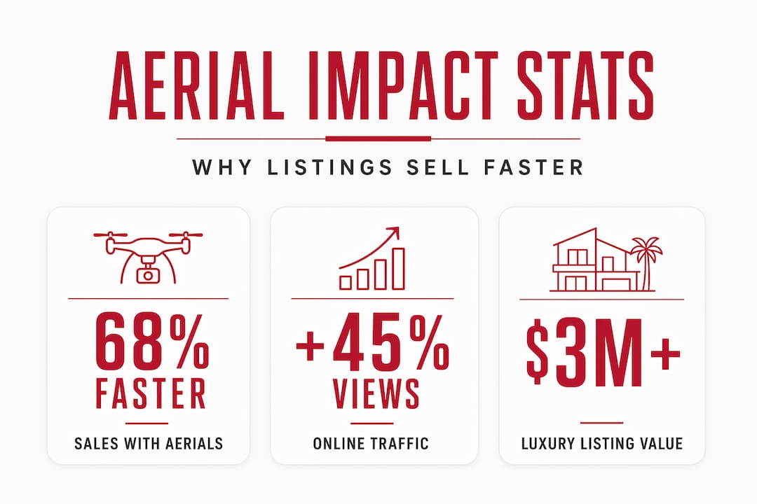
In luxury markets like La Jolla and Rancho Santa Fe, where properties regularly list above $3 million, even a modest reduction in days on market translates to significant carrying cost savings for the seller. Aerial photography is not a $400 expense. It is a risk management tool that protects the seller's position in a competitive environment.

FAA compliance and drone regulations
Here is where many agents and sellers get into trouble. Aerial photography for real estate is not a matter of buying a consumer drone and flying it over the property. Commercial drone use in the United States requires FAA Part 107 certification, drone registration, and strict compliance with altitude limits and airspace restrictions.
The rules are specific. Drone pilots must hold a Remote Pilot Certificate issued by the FAA. Flights are generally limited to 400 feet above ground level. Operations near airports, helipads, or controlled airspace require LAANC authorization or a formal waiver. In dense luxury markets like coastal Southern California, airspace restrictions are common and require advance planning.
Beyond federal rules, local restrictions add another layer:
- Many HOA communities in areas like Rancho Santa Fe prohibit drone flights over common areas or neighboring parcels
- Some municipalities require permits for commercial aerial photography on private property
- Coastal properties may fall under additional environmental review requirements
- Gated communities often require written permission from the homeowners association before any aerial shoot
The risks of non-compliance go beyond fines. Footage captured illegally cannot be used commercially, and attempting to do so exposes the agent and seller to liability. Professional drone operators who show FAA certification and compliance build buyer and broker trust, reinforcing the legitimacy of the listing itself.
Pro Tip: In dense or restricted markets, plan for multi-day coordination. LAANC approvals, HOA permissions, and weather windows can each add delays independently. Build at least two weeks of lead time into your aerial photography schedule for any luxury listing in a controlled airspace zone.
Integrating aerial photography into your marketing strategy
Aerial stills alone are not a marketing strategy. The impact of aerial photography multiplies when it is integrated into a cohesive visual package that guides the buyer from first impression to emotional commitment.
Here is a proven integration sequence for luxury listings:
- Lead with the aerial. Use the most compelling aerial shot as the hero image on MLS, your listing landing page, and social media. It establishes scale and setting immediately.
- Follow with exterior ground shots. Transition the buyer from the bird's-eye context to the human-scale experience of approaching and entering the property.
- Move through the interior. High-end real estate photography of interior spaces should flow logically through the home, reinforcing the lifestyle story the aerial established.
- Close with twilight imagery. Twilight aerials and exterior shots create emotional resonance and are consistently among the highest-performing images for luxury listings on social platforms.
- Add video or a 360 tour. Combining drone imagery with traditional media builds an engaging story that increases inquiries and buyer interest significantly.
One compliance issue that catches agents off guard involves MLS submission. MLS platforms enforce strict rules on drone imagery overlays, sizing, and metadata. An aerial image with a branded watermark or an embedded compass overlay may be rejected outright. Prepare two versions of every aerial image: one clean version for MLS submission and one branded version for social media and print marketing.
Intellectual property is another consideration worth taking seriously. Improper use of drone imagery can lead to disputes over publication rights, particularly when footage is repurposed across marketing channels or used in competitive advertising. Establish clear usage rights in your contract with the drone operator before the shoot.
When aerial photography adds the most value
Not every luxury listing benefits equally from aerial coverage. Understanding where the investment pays off helps agents allocate their marketing budget with precision.
Properties that gain the most from aerial imagery share a few characteristics:
- Large lot size, generally one acre or more, where the full footprint cannot be communicated any other way
- Unique outdoor amenities like equestrian facilities, vineyards, private docks, or resort-style pool complexes
- Premium view corridors, including ocean, canyon, mountain, or city views that are best understood from elevation
- Rural or semi-rural estate settings where terrain, privacy, and land use are central to the value proposition
- Waterfront or hillside positioning where the relationship between the structure and the land is the story
Aerial photography offers limited advantage for properties on small urban lots, attached condominiums, or townhomes where the lot boundaries and setting are already obvious from street level. Redundant aerial coverage on small or urban lots yields limited benefit and can actually dilute the visual impact of the listing by adding images that do not tell a meaningful story.
Aerial imagery investment for luxury shoots typically ranges from $250 to $600, with higher costs for twilight sessions, large acreage, or combined still and video packages. Against a $4 million listing, that cost is negligible if it contributes to a faster sale or a stronger negotiating position.
My perspective on aerial photography in luxury real estate
I have been marketing luxury properties in Southern California for over 15 years, and I have watched aerial photography shift from a novelty to a baseline expectation among serious buyers. What I have learned is that most agents still use it wrong.
The mistake I see repeatedly is treating aerial shots as the final polish on a listing rather than the foundation of its visual story. I start every luxury listing conversation by asking what the aerial will reveal, because that shapes everything else. If the property has a view that only makes sense from above, that view becomes the lead image and the emotional anchor for the entire campaign.
I have also seen the compliance side go badly wrong. An agent in a neighboring market used footage from an uncertified operator in a restricted airspace zone. The listing got traction, then the footage had to be pulled, and the disruption to the marketing momentum was real and costly. Certification is not bureaucratic overhead. It is protection for the seller and the agent.
What I believe is coming next is interactive aerial mapping integrated directly into listing pages, where buyers can explore the property and its surroundings in a single interface. The agents who understand how to tell a property's story from the air will be the ones buyers seek out when the market gets competitive.
— Stu
See luxury listings through a new lens with Stuharveyestates
At Stuharveyestates, aerial photography is part of how every qualifying luxury listing gets presented, not an optional add-on. Stu Harvey's team works with certified drone operators, manages all compliance requirements, and integrates aerial imagery into a full visual marketing package designed to attract serious buyers faster. Whether you are selling a coastal estate in La Jolla or a sprawling property in Rancho Santa Fe, the aerial perspective is often what makes a buyer stop scrolling and start inquiring. Explore current luxury listings to see how aerial photography and high-end real estate photography work together in practice. You can also browse the full property portfolio or connect with Stu directly to discuss how aerial imagery can be part of your listing strategy. If you are a buyer researching the San Diego luxury market, aerial views give you the context you need to evaluate properties before you ever visit.
FAQ
What is the role of aerial photography in luxury listings?
Aerial photography in luxury listings goes beyond aesthetics. It communicates lot scale, outdoor amenities, view corridors, and neighborhood context in ways ground-level photos cannot, helping buyers self-qualify and arrive at showings more prepared.
Do drone operators need FAA certification for real estate photography?
Yes. Commercial drone use for real estate requires FAA Part 107 certification and drone registration. Flights must comply with altitude limits and airspace regulations, with LAANC authorization required near controlled airspace.
How much does aerial photography cost for a luxury listing?
Aerial photography for luxury listings typically ranges from $250 to $600, depending on property size, media type, and session complexity. Twilight shoots and large acreage properties generally fall at the higher end.
Which luxury properties benefit most from aerial photography?
Properties with large lots, premium views, unique outdoor amenities, waterfront positioning, or rural settings gain the most from aerial imagery. Small urban lots and attached condominiums see limited benefit from aerial coverage.
Can aerial images be submitted directly to the MLS?
Not always without preparation. MLS platforms enforce rules on image overlays, branding, and metadata. Agents should prepare a clean, unbranded version for MLS submission and a separate branded version for social media and marketing materials.